HELP | Campus Map
Wayfinding
 Point-to-Point Walking and Driving directions are now available on the Campus Map.
- Navigate to the Campus Map from the Mt. SAC homepage, through the mobile app, or directly at www.mtsac.edu/campusmap.
- Click the
 Directions and Wayfinding button or tap Wayfinding on a mobile device.
 - Enter a Starting Point.
- Enter a Destination.

- Select
 Walking, Bicycling, or
  Driving Directions
- Optionally, click Show only accessible routes to display the most accessible route.
- Optionally, Driving Directions will combine a result for driving, parking, walking to your destination.

(You can move the parking pin location to other parking lots.)
- Click Get Directions.
Note: Some routes may appear to go through building walls, this is usually because the walkway passes behind buildings in a 3D space. Also consider, some routes may enter from one level and exit another level. When the accessible routes option is enabled, we attempt to provide a general path of travel to the nearest elevator. If a route is incorrect, please tell us the issue and any suggestions you may have.
Campus Map Features include:
- Saved Places - Saved Places
 allows mobile end users to save a custom pin location or parking spot on their mobile
device session. Once saved, you may share or get directions to that location later.
Save your favorite places (classes, clubs, activities, and more). (Locations are saved
in the browser cache of the device you are using, if you delete your cache, the locations
will reset.)
allows mobile end users to save a custom pin location or parking spot on their mobile
device session. Once saved, you may share or get directions to that location later.
Save your favorite places (classes, clubs, activities, and more). (Locations are saved
in the browser cache of the device you are using, if you delete your cache, the locations
will reset.) - Drag-and-Drop Pins let visitors customize routes.
- Wheelchair Accessible Route show the best possible route for a wheelchair (also accounting for elevation changes when possible).
- Point-to-Point Directions and Map can be copied and sent in a text message or email.
- Mobile-Friendly Directions work great on a mobile phone.
- Your location available pressing the
 location icon.
 - Directional location marker if phone is
 GPS capable, you can see the orientation of your phone on the map.
 - Driving Directions display route to nearest parking lot and walking directions from there. You can move the icon to another parking lot.
(This doesn't take into account parking rules and regulations by lot) - Construction-Free Routes are updated regularly in the notifications category.
- Events like commencement, major athletics events, planetarium shows, and more each have specific map overlays available. These are available from the Events drop down menu or map links menu in the footer on mobile devices.
Navigate Mt. SAC with Ease
Mt. SAC's interactive campus map makes getting around campus simple. It offers more features than a printed map and works on both your phone and computer. Whether you’re heading to class, looking for student services, or exploring campus resources, the map helps you find what you need fast. It even provides turn-by-turn walking directions. The map is updated regularly with accessible routes around construction, events, and road closures, so you’ll always know the best way to get where you’re going. Once you arrive on campus, the map gives walking directions from your parking spot or drop off point to your classroom.
Interface
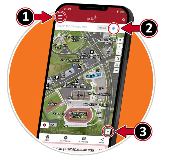
- The map directory is hidden on Mobile devices, select other map categories at #1.
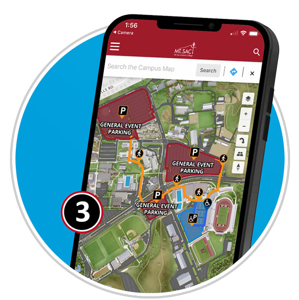
- Select the icon at #2 to select A to B Walking Directions.
- Select #3 to display your location on the campus map. (You must allow your browser to use your location on your mobile device)
 Home | Default View of the Campus Map
 Layers | Map/Satellite Views
 Zoom 0-20 (20 = 100% Zoom) | Zooming to 100% turns on the most detailed labels.
  Rotate Map | Rotate to West, South, East, and back to North
 Tilt Map | Change Angle.
 Compass | Displays direction of north, clicking returns back to North
- Location | Uses GPS to display location and direction of mobile device on map.
- Saved Places | Add your own locations to the campus map on your mobile device. (Saved to your
browser cache)
Selecting Map Categories
-
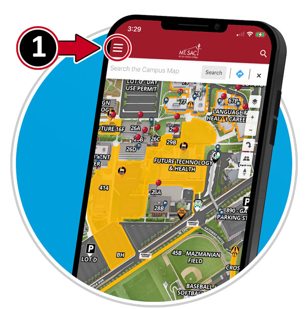
- The map directory is hidden on Mobile devices, select a category at #1
Example: Event Parking and Directions / Commencement
- The map directory is hidden on Mobile devices, select a category at #1
-
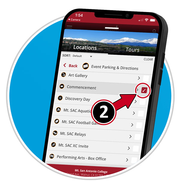
- Select the icon at #2 to select a desired category.
-
- View your selection
Default Marker Icons
Click markers to view detailed information about location.
 Elevators | Wayfinding for accessible paths will route to building elevators.
  Parking Lots/Parking Structures
 Transit Only Entrance
 Transit Center
 Bus Stops
How do I share the Map
Can I just copy the URL in the browser?
The URL in the web browser will not render the same map view. Always use the share button. There are two options available.
- There is a share button in the Red/Maroon header, this is for sharing the view you see on screen.
- When sharing a specific building or location, click on the share button on the location detail pop-up.
- You now have the option of a QR Code, Web Link, or Embed a map in a web page.
Embed Static Map into Web Page?
Insert a static location map inside your layout. Best to use a 2-3 column layout snippet. Button links to location on map.
- Find your location ID from the Share Button.
- In the CMS, locate the Campus Map Component, components appear on the toolbar like an atom
LiveWhale (Campus Calendar)
- Use the ID from the method above, then insert the following code into the code view
of LiveWhale Calendar Entry.
<embed style="border: 0px solid #fff; margin: 0; padding: 0;" title="Mt. San Antonio College" src="https://campusmap.mtsac.edu/?id=811#!m/772918" width="600" height="600" />
Embed Dynamic map into Web Page?
For the best results, add the embedded map to the "full width" section of your page. You can enable this option in the Modern Campus CMS properties for the specific page. We recommend reaching out to the web team for Implementation as most users do not have source-code access.
- Add Script to "footcode" that requires clicking the map to interact.
<!-- Require clicking map to interact script --> <script> $(document).ready(function() { $('#map').css('pointer-events', 'none'); $('.map-wrapper').click(function() { $(this).find('#map').css('pointer-events', 'auto'); // just $('#map') also fine }); $('.map-wrapper').mouseleave(function() { $(this).find('#map').css('pointer-events', 'none'); // making it not clickable when it's not in focus }); }); </script> - Add Embed Code
<div class="map-wrapper" style="height: 100vh;">

<iframe id="map" style="border: 0px solid #fff; margin: 0; padding: 0;" title="Map Name" src="https://campusmap.mtsac.edu?id=811#!ce/70789?ct/71552,70569,57333,56213,55748,32093,32081,12302,50736,53294,70789,91270,91273,91271,91272,91269?m/761626?s/?sbc/?mc/34.05193665745425,-117.84011146414218?z/20?lvl/0?p/60?b/0" name="campusmap" width="100%" height="100%"  scrolling="no" allow="geolocation; gyroscope; accelerometer"></iframe>

</div>
Looking for a Specific Map
- Access | Disabled Parking, Elevators, Ramps, Restrooms
- Notices | Temporary Closures, Drills, Outages, Major Events
- Directory | Academic Divisions, Departments, Services, Event Locations, Tutoring, Labs, and more.
- Essentials | Food & Stores, Water Bottle Filling Stations, Free Menstrual Product Dispensers, Restrooms, Lactation Accommodations, Basic Needs
- Events | Art Gallery, Athletic Events, Planetarium/Observatory, Plant Sales, Farmers Market (Saturdays)
- District Map | The District boundary is broken into 7 areas for each of the 7 elected board members.
- Sustainability
- Construction | Construction Fences, Closures, Road Work, Remodeling, and more.
- Parking & Transportation
- Transit Bus Stops and Transit Center
- Safety & Emergency + Assembly Areas
Updates/Corrections
The online Campus Map is continuously updated, we also rely on you for your assistance too. If you are student or employee of Mt. SAC and find information on the map that needs to be updated, please submit an IT Helpdesk Ticket for a Campus Map update. For the general public, please use the Web Feedback Form and provide as much detail as possible. If you have a map on your web page and this breaks, please let me know. Anytime there is reorganization of the map or new details, the links may change. We would be happy to work with you on a fix.
Note: If you have a map link or embedded map that is missing labels, please create a HelpDesk Ticket for assistance.
Print Maps
There are times an interactive map just isn't the right tool to find your way. We understand. This is also a perfect map for printing then submitting campus map updates. Here's some of the printable maps we have available.
Campus Map Kiosk
There are 15 Campus Map Kiosks around the Campus. Online map is updated daily.
Letter Sized Map
This map is formatted for printing on personal printers on 8.5x11 inch printers.
Pocket Map
Foldable pocket maps are available from the Marketing Office in bundles of 50. Please connect with Cynthia Orr (corr@mtsac.edu) to let her know how many you need.
